Autherley to Chester / Ellesmere Port
Cruise at your leisure through unspoilt countryside through picturesque villages and towns with the historic city of Chester or the boat museum at Ellesmere Port as your turning point, or Nantwich if you want a more leisurely trip.
Scroll down for details
We are currently running some special offers, Click here for more info
These route suggestions are offered in good faith and to the best of our knowledge. It is up to you to decide on your own stops and to ensure you return to the base at the agreed time.
we recommend you also check for current stoppages on the CRT website that may affect your choice of route
Shropshire Union Canal
Autherley to Brewood
Points of Interest
Brewood
Charming village with 13th Century Church and interesting Gothic style speedwell Castle.
Pictures: click for a bigger image


Location: On Google Maps
Best Access From: Bridge 14, Click for Route Map.
- OS. Grid ref.: SJ883 088
Points of Interest in Brewood
Bridge Inn
A dog and family friendly canal side pub. Food served daily.
Pictures: click for a bigger image

Location: On Google Maps
Best Access From: Bridge 14, Click for Route Map.
- Postcode: ST199BD
Spar Shop, Brewood
Handy store for provisions
Brewood to the Anchor Inn, High Offley
Points of Interest
Wheaton Aston Visitor Moorings
A small village in Staffordshire, England about 9 miles (14 km) south west of Stafford.
Points of Interest in Wheaton Aston Visitor Moorings
The Hartley Arms
A great range of real-ales, hand picked wines and contemporary cocktails. We serve a traditional comfort style pub menu complimented by daily specials which you can enjoy in a more traditional restaurant area, in the bar or overlooking the canal in our all weather beer garden.
Dogs welcome.
Pictures: click for a bigger image

Location: On Google Maps
Best Access From: Tavern Bridge (19), Click for Route Map.
Doal Food & News
Small Shop but stocks a wide range of goods. Also doubles as a post office.
Location: On Google Maps
Best Access From: Tavern Bridge (19), Click for Route Map.
Spar Shop, Wheaton Aston
Great Spar and well stocked, friendly and welcoming staff.
Not too far from the canal and located in the centre of the village opposite the lovely little square.
Location: On Google Maps
Best Access From: Tavern Bridge (19), Click for Route Map.
Coach and Horses
Dog friendly Marston's Sport's Pub, about half a mile from the canal.
Location: On Google Maps
Best Access From: Tavern Bridge (19), Click for Route Map.
Gnosall Heath
A village in Staffordshire handy for the amenities it offers to passing boaters.
Location: On Google Maps
Best Access From: Boat Inn Bridge (34), Click for Route Map.
Points of Interest in Gnosall Heath
Boat Inn, Gnosall
The Boat Inn is a proper local, with great beer, a cosy atmosphere, real fires, delicious homemade food and classic pub grub.
And we love dogs as much as people!
Pictures: click for a bigger image

Location: On Google Maps
Best Access From: Boat Inn Bridge (34), Click for Route Map.
Gnosall Express
Convenience Store close to the canal.
Location: On Google Maps
Best Access From: Boat Inn Bridge (34), Click for Route Map.
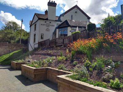
The Navigation Inn, Gnosall
The Navigation Inn is a charming village pub and restaurant with a large beer garden with beautiful canalside views, perfect for Al fresco dining in the summer. Our lovely team are ready to welcome you and make your visit a memorable one!
Pictures: click for a bigger image
Location: On Google Maps
Best Access From: Gnosall Bridge (35), Click for Route Map.
Gnosall Fish Bar
Kebabs, Fish & Chips
Location: On Google Maps
Best Access From: Gnosall Bridge (35), Click for Route Map.
Junction Inn, Norbury
Home-cooked food, local ales and idyllic canal side views. We allow well behaved dogs, kept on a lead in our bar and beer garden.
Pictures: click for a bigger image
Location: On Google Maps
Best Access From: Canal Towpath, Click for Route Map.
The Anchor Inn, High Offley
Canalside pub
Anchor Inn to Audlem
Points of Interest
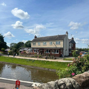
The Wharf Tavern, Goldstone
As well as a good selection of cask ales and beers, global wines and a variety of spirits, we offer traditional home cooked meals, made with fresh ingredients sourced locally. Bookings by telephone only. PLEASE NOTE DOGS ARE NOT ALLOWED INSIDE THE PUB.
Pictures: click for a bigger image

Location: On Google Maps
Best Access From: Goldstone Bridge (55), Click for Route Map.
Market Drayton
Pretty town of half-timbered buildings, handsome church.
Market Day Wednesday: Early Closing Thursday.
Pictures: click for a bigger image

Location: On Google Maps
Best Access From: Newcastle Road Bridge (62), Click for Route Map.
Points of Interest in Market Drayton
The Red Lion, Market Drayton
The Red Lion, Joule's flagship Brewery Tap, adjoins the Brewery itself. The pub dates back to 1623 and has been sympathetically restored to encompass the new Brewery which has been built on a half-acre site behind the ancient pub.
Pictures: click for a bigger image

Location: On Google Maps
Best Access From: Berrisford Canal Aqueduct, Click for Route Map.
Asda, Market Drayton
Small supermarket hand for provisions.
Location: On Google Maps
Best Access From: Bridge 62, Click for Route Map.
Audlem Top Lock Visitor moorings
A mooring in the countryside above the top lock of the Audlem flight (15 locks).
Location: On Google Maps
Audlem
A village in Cheshire and a significant canal location with it's flight of 15 locks and associated architecture.
Location: On Google Maps
Best Access From: Audlem Bridge (78), Click for Route Map.
Points of Interest in Audlem
The Shroppie Fly
Traditional Inn & Dining, named after the "Fly Boats" that used to work non-stop on the canal delivering urgent cargos. Family and pet friendly.
Pictures: click for a bigger image


Location: On Google Maps
Best Access From: Canal Towpath, Click for Route Map.
The Bridge Inn, Audlem
A Marston's "Sky Sports" pub next to the canal.
Pictures: click for a bigger image

Location: On Google Maps
Best Access From: Canal Towpath, Click for Route Map.
Audlem Co-op convenience store
Handy shop close to the canal for topping up your provisions.
Location: On Google Maps
Best Access From: Audlem Bridge (78), Click for Route Map.
Ayaans Indian Takeaway
Indian takeaway close to the canal, with online ordering.
Location: On Google Maps
Best Access From: Audlem Bridge (78), Click for Route Map.
The Lord Combermere
A freehouse where you you can expect a warm welcome, wonderful wine and fine food.
We are dog friendly in the bar area and have dog treats for your furry friends!
Location: On Google Maps
Best Access From: Audlem Bridge (78), Click for Route Map.
The Village Chippy
Traditional Fish & Chips shop
Location: On Google Maps
Best Access From: Audlem Bridge (78), Click for Route Map.
13 miles, 10 locks and 7 hours cruising to just above Audlem Top Lock.
Audlem to Nantwich
Points of Interest
Hack Green Secret Nuclear Bunker
Hidden deep in the Cheshire countryside, the bunker stayed secret for more than 50 years. Now the blast doors are open and you can discover the labyrinth of rooms and authentic equipment used to run this defence region in the event of a National Emergency.
Pictures: click for a bigger image

Location: On Google Maps
Best Access From: Burrows Bridge (85), Click for Route Map.
Nantwich
One of England's loveliest market towns, with half-timbered buildings and narrow winding streets.
Of special interest - Parish Church considered "The Cathedral of South Cheshire" for its size, beauty, fabulous wood and stone carvings, contemporary needlework and lovely glass.
Pictures: click for a bigger image


Location: On Google Maps
Best Access From: Public Moorings, Click for Route Map.
Points of Interest in Nantwich
Churche's Mansion
16th Century timbered town house. Open to view.
Churche's Mansion was built in 1577 for a wealthy merchant and remains in wonderful condition with many original features. It is Grade I Listed, with a wealth of history to enjoy both inside and out. It is very rare for a merchant's house to have survived in such original condition for over 430 years.
Pictures: click for a bigger image

Location: On Google Maps
Best Access From: Public Moorings, Click for Route Map.
Nantwich Museum
The fascinating history of one of Cheshire's most attractive and historic towns is brought to life by Nantwich Museum.
Located in Pillory Street, at the heart of the town, the museum has main galleries telling the story of Nantwich through the ages - Roman salt making, Tudor Nantwich's Great Fire, the Civil War Battle of Nantwich (1644) and the more recent shoe and clothing industries.
Pictures: click for a bigger image

Location: On Google Maps
Best Access From: Public Moorings, Click for Route Map.
Dorfold Hall
A Jacobean house built in 1616, with beautifully-plastered ceilings, oak panelling and woodland garden.Open from April to end of October Tuesdays and Bank Holiday
Pictures: click for a bigger image


Location: On Google Maps
Best Access From: Public Moorings, Click for Route Map.
- Postcode: CW58LD
The Oddfellows Arms
Enjoy our historic pub by the canal with a large beer garden, dog-friendly atmosphere, and a warm interior. Perfect for family gatherings, casual drinks, and local events
Pictures: click for a bigger image

Location: On Google Maps
Best Access From: Visitor moorings on the embankment, Click for Route Map.
Welsh Row Fryer
Fish and Chips shop
Location: On Google Maps
Best Access From: Visitor moorings on the embankment, Click for Route Map.
Wilbraham Arms
Friendly local pub showing all live sports, dog friendly and fantastic homemade food.
Pictures: click for a bigger image

Location: On Google Maps
Best Access From: Visitor moorings on the embankment, Click for Route Map.
Morrisons, Nantwich
Large Chain Supermarket
Location: On Google Maps
Best Access From: Visitor moorings on the embankment, Click for Route Map.
Aldi, Nantwich
Large chain supermarket
Location: On Google Maps
Best Access From: Visitor moorings on the embankment, Click for Route Map.
Nantwich to Chester
Points of Interest
Bunbury Mill
Restored 17th Century Watermill
Bunbury Mill is a beautifully restored water mill standing in two acres of wildlife rich countryside.
Now owned by a village trust the mill has been re-opened and given a fresh lease of life creating the perfect place for people of all ages to visit.
The mill is open on Sunday afternoons and for pre-arranged group or school visits.
Pictures: click for a bigger image

Location: On Google Maps
Best Access From: Bridge 105, Click for Route Map.
- Postcode: CW69PP
Beeston Castle
13th Century fortress scene of battle in time of Henry II and twice during Civil War
Many interesting stories attaching to the well - explored to 360' depth in search of King Richard II's treasure - searches made in 1842 and 1935. Panoramic view
Pictures: click for a bigger image


Location: On Google Maps
Best Access From: Bridge 108 footpath, Bridge 109 road, Click for Route Map.
The Shady
The Shady is a beautiful canalside country pub nestled on The Shropshire Union Canal. With stunning views of, and short walks to both Beeston and Peckforton Castles, this pub is one of Cheshire's best known and much-loved destinations.
Pictures: click for a bigger image

Location: On Google Maps
Best Access From: Bate's Mill Bridge (109), Click for Route Map.
The Cheshire Cat, Christleton
Traditional country inn offering a pub with a restaurant and a beer garden, plus casual, warm rooms.
Pictures: click for a bigger image

Location: On Google Maps
Best Access From: Towpath moorings outside, Click for Route Map.
Christleton Stores & Newsagents
Handy shop a short walk from the canal.
Location: On Google Maps
Best Access From: Pepper Street Bridge (122), Click for Route Map.
Ring O' Bells, Christleton.
Relaxed pub and conservatory dining on British favourites, pizza and salads, plus regular events.
Pictures: click for a bigger image

Location: On Google Maps
Best Access From: Pepper Street Bridge (122), Click for Route Map.
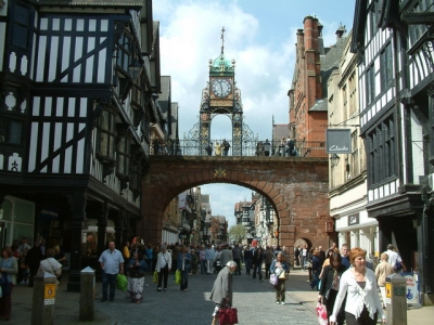
Chester
Royal City founded by the Romans and celebrating over 1900 years of history
Chester has a number of mediaeval buildings, but some of the black-and-white buildings within the city centre are actually Victorian restorations. Chester is one of the best preserved walled cities in Britain. Apart from a 100-metre (330 ft) section, the listed Grade I walls are almost complete.
Pictures: click for a bigger image


Location: On Google Maps
Best Access From: Visitor Moorings, Click for Route Map.
Points of Interest in Chester
Chester Cathedral
Chester Cathedral has a rich and fascinating heritage.
The cathedral is a Grade I listed building, and part of a heritage site that also includes the former monastic buildings to the north, also listed Grade I. The cathedral, typical of English cathedrals in having been modified many times, dates from between 1093 and the early 16th century, although the site itself may have been used for Christian worship since Roman times. All the major styles of English medieval architecture, from Norman to Perpendicular, are represented in the present building.
Pictures: click for a bigger image


Location: On Google Maps
Best Access From: Public Moorings, Click for Route Map.
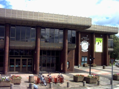
Northgate Arena Leisure Centre
For swimming, gym etc.
Pictures: click for a bigger image
Location: On Google Maps
Best Access From: Public Moorings, Click for Route Map.
Tesco Superstore, Chester
Large chain supermarket, right next to the canal.
Location: On Google Maps
Best Access From: Canal Towpath, Click for Route Map.
Chester to Ellesmere Port
Points of Interest
Telford's Warehouse
Canalside bar and restaurant hosting live music and arts venue, serving real ales plus pub grub.
Pictures: click for a bigger image

Location: On Google Maps
Best Access From: Towpath Moorings, Click for Route Map.
Chester Zoo
Chester Zoo is one of the world's top zoos, and the UK's number one wildlife attraction.
It was opened in 1931 by George Mottershead and his family, who used as a basis some animals reported to have come from an earlier zoo in Shavington. It is one of the UK's largest zoos with a total land holding of approximately 400 acres (160 ha).
Pictures: click for a bigger image


Location: On Google Maps
Best Access From: Bridge 134, Click for Route Map.
- What3Words: one/two/three
Ellesmere Port Boat Museum
With its stunning location on the banks of the Mersey and the Manchester Ship Canal, extensive in-door displays, boat trips and historic buildings, the museum makes a great family day out in Cheshire, where time slows down and history comes to life.
There's so much to explore from the handsome Victorian buildings, which house the museum's displays, to the locks and moorings vibrant with historic and visiting narrow boats. With a year-round events calendar featuring everything from beer festivals to historic boat rallies, there's always a reason to visit.
Designed by Thomas Telford under the direction of William Jessop, the docks at Ellesmere Port were still in use as late as the 1950s. They were a marvellously self-contained world and when you visit the museum today you can still walk round its locks, docks and warehouses and visit its forge, stables and workers cottages.
Pictures: click for a bigger image


Location: On Google Maps
Best Access From: The port itself!, Click for Route Map.
Horse and Jockey, Ellesmere Port
A family run pub with great beer at amazing prices, a good atmosphere and friendly locals + TNT SPORTS
Location: On Google Maps
Best Access From: Canal Towpath, Click for Route Map.
Ellesmere Port to Beeston
Points of Interest
Chester Zoo
Chester Zoo is one of the world's top zoos, and the UK's number one wildlife attraction.
It was opened in 1931 by George Mottershead and his family, who used as a basis some animals reported to have come from an earlier zoo in Shavington. It is one of the UK's largest zoos with a total land holding of approximately 400 acres (160 ha).
Pictures: click for a bigger image
Location: On Google Maps
Best Access From: Bridge 134, Click for Route Map.
- What3Words: one/two/three
Chester
Royal City founded by the Romans and celebrating over 1900 years of history
Chester has a number of mediaeval buildings, but some of the black-and-white buildings within the city centre are actually Victorian restorations. Chester is one of the best preserved walled cities in Britain. Apart from a 100-metre (330 ft) section, the listed Grade I walls are almost complete.
Pictures: click for a bigger image
Location: On Google Maps
Best Access From: Visitor Moorings, Click for Route Map.
Points of Interest in Chester
Chester Cathedral
Chester Cathedral has a rich and fascinating heritage.
The cathedral is a Grade I listed building, and part of a heritage site that also includes the former monastic buildings to the north, also listed Grade I. The cathedral, typical of English cathedrals in having been modified many times, dates from between 1093 and the early 16th century, although the site itself may have been used for Christian worship since Roman times. All the major styles of English medieval architecture, from Norman to Perpendicular, are represented in the present building.
Pictures: click for a bigger image
Location: On Google Maps
Best Access From: Public Moorings, Click for Route Map.
Northgate Arena Leisure Centre
For swimming, gym etc.
Pictures: click for a bigger image
Location: On Google Maps
Best Access From: Public Moorings, Click for Route Map.
Tesco Superstore, Chester
Large chain supermarket, right next to the canal.
Location: On Google Maps
Best Access From: Canal Towpath, Click for Route Map.
Ring O' Bells, Christleton.
Relaxed pub and conservatory dining on British favourites, pizza and salads, plus regular events.
Pictures: click for a bigger image
Location: On Google Maps
Best Access From: Pepper Street Bridge (122), Click for Route Map.
Christleton Stores & Newsagents
Handy shop a short walk from the canal.
Location: On Google Maps
Best Access From: Pepper Street Bridge (122), Click for Route Map.
The Cheshire Cat, Christleton
Traditional country inn offering a pub with a restaurant and a beer garden, plus casual, warm rooms.
Pictures: click for a bigger image
Location: On Google Maps
Best Access From: Towpath moorings outside, Click for Route Map.
The Shady
The Shady is a beautiful canalside country pub nestled on The Shropshire Union Canal. With stunning views of, and short walks to both Beeston and Peckforton Castles, this pub is one of Cheshire's best known and much-loved destinations.
Pictures: click for a bigger image
Location: On Google Maps
Best Access From: Bate's Mill Bridge (109), Click for Route Map.
Beeston Castle
13th Century fortress scene of battle in time of Henry II and twice during Civil War
Many interesting stories attaching to the well - explored to 360' depth in search of King Richard II's treasure - searches made in 1842 and 1935. Panoramic view
Pictures: click for a bigger image
Location: On Google Maps
Best Access From: Bridge 108 footpath, Bridge 109 road, Click for Route Map.
Beeston to Audlem
Points of Interest
Bunbury Mill
Restored 17th Century Watermill
Bunbury Mill is a beautifully restored water mill standing in two acres of wildlife rich countryside.
Now owned by a village trust the mill has been re-opened and given a fresh lease of life creating the perfect place for people of all ages to visit.
The mill is open on Sunday afternoons and for pre-arranged group or school visits.
Pictures: click for a bigger image
Location: On Google Maps
Best Access From: Bridge 105, Click for Route Map.
- Postcode: CW69PP
Nantwich
One of England's loveliest market towns, with half-timbered buildings and narrow winding streets.
Of special interest - Parish Church considered "The Cathedral of South Cheshire" for its size, beauty, fabulous wood and stone carvings, contemporary needlework and lovely glass.
Pictures: click for a bigger image
Location: On Google Maps
Best Access From: Public Moorings, Click for Route Map.
Points of Interest in Nantwich
Churche's Mansion
16th Century timbered town house. Open to view.
Churche's Mansion was built in 1577 for a wealthy merchant and remains in wonderful condition with many original features. It is Grade I Listed, with a wealth of history to enjoy both inside and out. It is very rare for a merchant's house to have survived in such original condition for over 430 years.
Pictures: click for a bigger image
Location: On Google Maps
Best Access From: Public Moorings, Click for Route Map.
Nantwich Museum
The fascinating history of one of Cheshire's most attractive and historic towns is brought to life by Nantwich Museum.
Located in Pillory Street, at the heart of the town, the museum has main galleries telling the story of Nantwich through the ages - Roman salt making, Tudor Nantwich's Great Fire, the Civil War Battle of Nantwich (1644) and the more recent shoe and clothing industries.
Pictures: click for a bigger image
Location: On Google Maps
Best Access From: Public Moorings, Click for Route Map.
Dorfold Hall
A Jacobean house built in 1616, with beautifully-plastered ceilings, oak panelling and woodland garden.Open from April to end of October Tuesdays and Bank Holiday
Pictures: click for a bigger image
Location: On Google Maps
Best Access From: Public Moorings, Click for Route Map.
- Postcode: CW58LD
The Oddfellows Arms
Enjoy our historic pub by the canal with a large beer garden, dog-friendly atmosphere, and a warm interior. Perfect for family gatherings, casual drinks, and local events
Pictures: click for a bigger image
Location: On Google Maps
Best Access From: Visitor moorings on the embankment, Click for Route Map.
Welsh Row Fryer
Fish and Chips shop
Location: On Google Maps
Best Access From: Visitor moorings on the embankment, Click for Route Map.
Wilbraham Arms
Friendly local pub showing all live sports, dog friendly and fantastic homemade food.
Pictures: click for a bigger image
Location: On Google Maps
Best Access From: Visitor moorings on the embankment, Click for Route Map.
Morrisons, Nantwich
Large Chain Supermarket
Location: On Google Maps
Best Access From: Visitor moorings on the embankment, Click for Route Map.
Aldi, Nantwich
Large chain supermarket
Location: On Google Maps
Best Access From: Visitor moorings on the embankment, Click for Route Map.
Hack Green Secret Nuclear Bunker
Hidden deep in the Cheshire countryside, the bunker stayed secret for more than 50 years. Now the blast doors are open and you can discover the labyrinth of rooms and authentic equipment used to run this defence region in the event of a National Emergency.
Pictures: click for a bigger image
Location: On Google Maps
Best Access From: Burrows Bridge (85), Click for Route Map.
Audlem
A village in Cheshire and a significant canal location with it's flight of 15 locks and associated architecture.
Location: On Google Maps
Best Access From: Audlem Bridge (78), Click for Route Map.
Points of Interest in Audlem
The Shroppie Fly
Traditional Inn & Dining, named after the "Fly Boats" that used to work non-stop on the canal delivering urgent cargos. Family and pet friendly.
Pictures: click for a bigger image
Location: On Google Maps
Best Access From: Canal Towpath, Click for Route Map.
The Bridge Inn, Audlem
A Marston's "Sky Sports" pub next to the canal.
Pictures: click for a bigger image
Location: On Google Maps
Best Access From: Canal Towpath, Click for Route Map.
Audlem Co-op convenience store
Handy shop close to the canal for topping up your provisions.
Location: On Google Maps
Best Access From: Audlem Bridge (78), Click for Route Map.
Ayaans Indian Takeaway
Indian takeaway close to the canal, with online ordering.
Location: On Google Maps
Best Access From: Audlem Bridge (78), Click for Route Map.
The Lord Combermere
A freehouse where you you can expect a warm welcome, wonderful wine and fine food.
We are dog friendly in the bar area and have dog treats for your furry friends!
Location: On Google Maps
Best Access From: Audlem Bridge (78), Click for Route Map.
The Village Chippy
Traditional Fish & Chips shop
Location: On Google Maps
Best Access From: Audlem Bridge (78), Click for Route Map.
Audlem to Goldstone Wharf
Points of Interest
Market Drayton
Pretty town of half-timbered buildings, handsome church.
Market Day Wednesday: Early Closing Thursday.
Pictures: click for a bigger image
Location: On Google Maps
Best Access From: Newcastle Road Bridge (62), Click for Route Map.
Points of Interest in Market Drayton
The Red Lion, Market Drayton
The Red Lion, Joule's flagship Brewery Tap, adjoins the Brewery itself. The pub dates back to 1623 and has been sympathetically restored to encompass the new Brewery which has been built on a half-acre site behind the ancient pub.
Pictures: click for a bigger image
Location: On Google Maps
Best Access From: Berrisford Canal Aqueduct, Click for Route Map.
Asda, Market Drayton
Small supermarket hand for provisions.
Location: On Google Maps
Best Access From: Bridge 62, Click for Route Map.
The Wharf Tavern, Goldstone
As well as a good selection of cask ales and beers, global wines and a variety of spirits, we offer traditional home cooked meals, made with fresh ingredients sourced locally. Bookings by telephone only. PLEASE NOTE DOGS ARE NOT ALLOWED INSIDE THE PUB.
Pictures: click for a bigger image
Location: On Google Maps
Best Access From: Goldstone Bridge (55), Click for Route Map.
Goldstone Wharf to Pendeford
Points of Interest
The Anchor Inn, High Offley
Canalside pub
Junction Inn, Norbury
Home-cooked food, local ales and idyllic canal side views. We allow well behaved dogs, kept on a lead in our bar and beer garden.
Pictures: click for a bigger image
Location: On Google Maps
Best Access From: Canal Towpath, Click for Route Map.
Gnosall Heath
A village in Staffordshire handy for the amenities it offers to passing boaters.
Location: On Google Maps
Best Access From: Boat Inn Bridge (34), Click for Route Map.
Points of Interest in Gnosall Heath
Boat Inn, Gnosall
The Boat Inn is a proper local, with great beer, a cosy atmosphere, real fires, delicious homemade food and classic pub grub.
And we love dogs as much as people!
Pictures: click for a bigger image
Location: On Google Maps
Best Access From: Boat Inn Bridge (34), Click for Route Map.
Gnosall Express
Convenience Store close to the canal.
Location: On Google Maps
Best Access From: Boat Inn Bridge (34), Click for Route Map.
The Navigation Inn, Gnosall
The Navigation Inn is a charming village pub and restaurant with a large beer garden with beautiful canalside views, perfect for Al fresco dining in the summer. Our lovely team are ready to welcome you and make your visit a memorable one!
Pictures: click for a bigger image
Location: On Google Maps
Best Access From: Gnosall Bridge (35), Click for Route Map.
Gnosall Fish Bar
Kebabs, Fish & Chips
Location: On Google Maps
Best Access From: Gnosall Bridge (35), Click for Route Map.
Wheaton Aston Visitor Moorings
A small village in Staffordshire, England about 9 miles (14 km) south west of Stafford.
Points of Interest in Wheaton Aston Visitor Moorings
The Hartley Arms
A great range of real-ales, hand picked wines and contemporary cocktails. We serve a traditional comfort style pub menu complimented by daily specials which you can enjoy in a more traditional restaurant area, in the bar or overlooking the canal in our all weather beer garden.
Dogs welcome.
Pictures: click for a bigger image
Location: On Google Maps
Best Access From: Tavern Bridge (19), Click for Route Map.
Doal Food & News
Small Shop but stocks a wide range of goods. Also doubles as a post office.
Location: On Google Maps
Best Access From: Tavern Bridge (19), Click for Route Map.
Spar Shop, Wheaton Aston
Great Spar and well stocked, friendly and welcoming staff.
Not too far from the canal and located in the centre of the village opposite the lovely little square.
Location: On Google Maps
Best Access From: Tavern Bridge (19), Click for Route Map.
Coach and Horses
Dog friendly Marston's Sport's Pub, about half a mile from the canal.
Location: On Google Maps
Best Access From: Tavern Bridge (19), Click for Route Map.
Brewood
Charming village with 13th Century Church and interesting Gothic style speedwell Castle.
Pictures: click for a bigger image
Location: On Google Maps
Best Access From: Bridge 14, Click for Route Map.
- OS. Grid ref.: SJ883 088
Points of Interest in Brewood
Bridge Inn
A dog and family friendly canal side pub. Food served daily.
Pictures: click for a bigger image
Location: On Google Maps
Best Access From: Bridge 14, Click for Route Map.
- Postcode: ST199BD
Spar Shop, Brewood
Handy store for provisions
Woodman Inn
Traditional British Pub, just over half a mile from the canal
Pictures: click for a bigger image

Location: On Google Maps
Best Access From: Pendeford Bridge (4), Click for Route Map.
The Olde Vicarage, Bilbrook
The Olde Vicarage in the heart of Bilbrook has been lovingly restored to provide a unique intimate venue home to The Olde Vic community micropub offering fine ales, wines and spirits along with traditional bar snacks.
Location: On Google Maps
Best Access From: Pendeford Bridge (4), Click for Route Map.
Bilbrook Fish Bar
A 5* rated food hygiene rated Fish & Chip shop
Location: On Google Maps
Best Access From: Pendeford Bridge (4), Click for Route Map.
Budgens
Supermarket chain selling own-label goods, plus well-known brands & meat from British farms.
Location: On Google Maps
Best Access From: Pendeford Bridge (4), Click for Route Map.
Pendeford to Autherley
Guidebooks / Maps

Pearson's Guide: Welsh Waters: Shropshire Union, Llangollen, Brecon and Montgomery Canals
This new edition of Michael Pearson's Welsh Waters Canal Companion focusses on the Llangollen, Montgomery and Monmouthshire & Brecon canals in Wales, and the Shropshire Union Canal in England. Over 200 miles of canals expertly interpreted to inspire you, on foot, afloat or by bicycle.
Contact Us
- Phone:
- +44 (0)1926 813644 (Calls may be recorded for monitoring purposes)
- Email:
- enquiries@napton-marina.co.uk
- Open:
- November to March - 8:30am to 5:00pm (GMT) - Monday to Friday.